batch may 11
voluntary submissions · build-as-confident · push-pin pinboard
EXIF GPS · 100%

Larsen Bay, Kodiak Island, Alaska
2nd Street · ZIP 99624 · 57.5381° N, -153.9921° W · alt 8m (sea level)
100% · EXIF GPS lock · triple-verified
[OBS] EXIF GPS intact (iPhone 6 original from 2017-08-11 21:49)
[OBS] vessel "TWO SAINTS · NEWPORT, OR" painted on stern · American flag
[OBS] coastal Alaska mountain silhouette · calm protected water · sunset light
[INF] Nominatim → 2nd Street, Larsen Bay, Kodiak Island Borough
[INF] Newport-OR-homeported boats fish Alaska seasons (vessel hailing port ≠ photo location)
3 independent confirmations: EXIF + signage + geography
open in maps →
[OBS] vessel "TWO SAINTS · NEWPORT, OR" painted on stern · American flag
[OBS] coastal Alaska mountain silhouette · calm protected water · sunset light
[INF] Nominatim → 2nd Street, Larsen Bay, Kodiak Island Borough
[INF] Newport-OR-homeported boats fish Alaska seasons (vessel hailing port ≠ photo location)
3 independent confirmations: EXIF + signage + geography
SIGN OCR · 92%
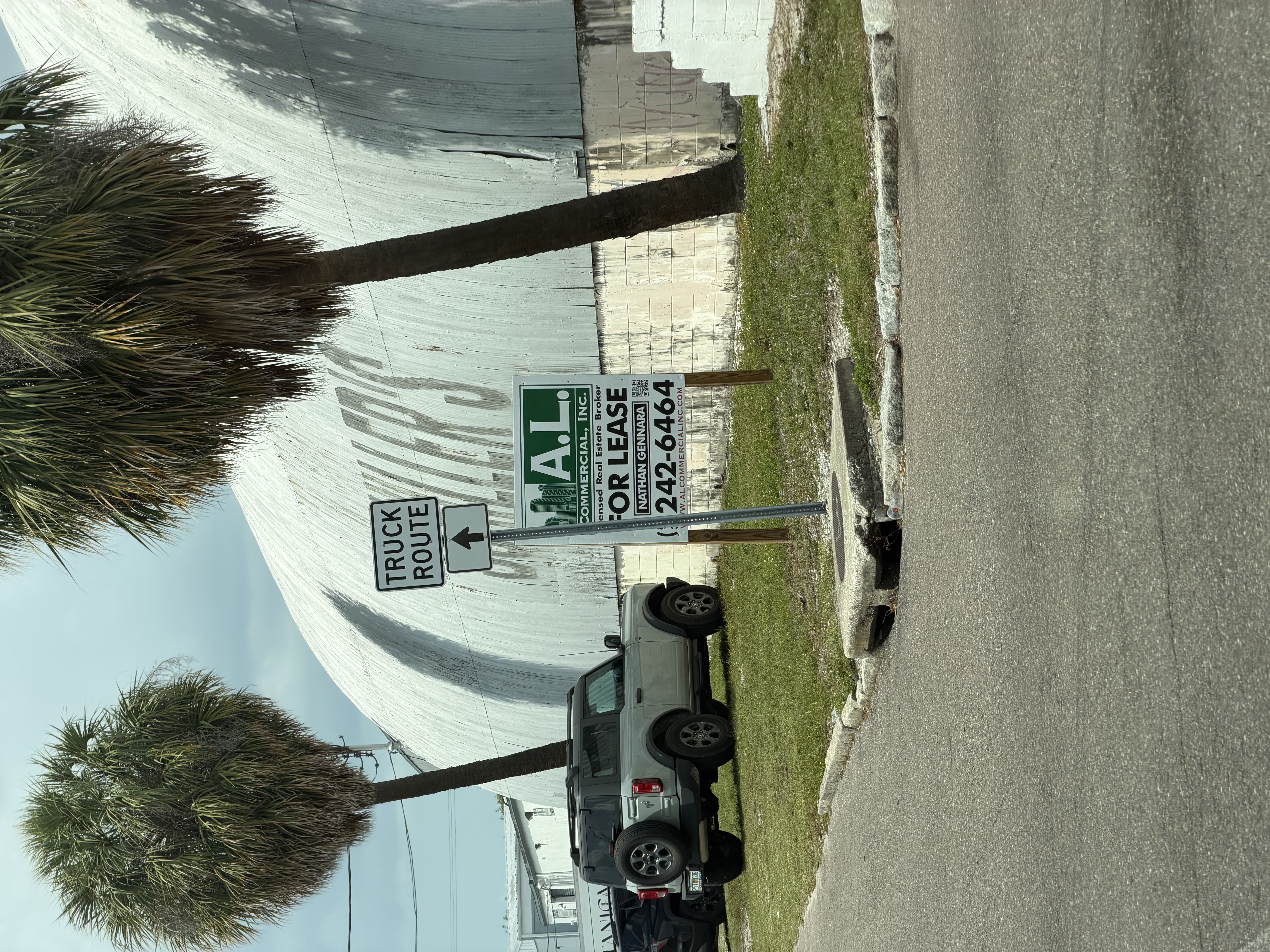
Tampa, FL
A.L. Commercial Inc listing · Hillsborough County · ~27.95°N, -82.46°W
92% · broker sign + 813 area code
[OBS] PIL crop on broker sign: "A.L. COMMERCIAL, INC / Nathan Gennara / 813-242-6464"
[INF] 813 area code = Tampa Bay metro · alcommercialinc.com confirms Tampa-only firm
[OBS] cabbage palms (Sabal palmetto) = FL biome confirmation
sign-text is ground truth (Phase 0.5 PIL crop tier)
open in maps →
[INF] 813 area code = Tampa Bay metro · alcommercialinc.com confirms Tampa-only firm
[OBS] cabbage palms (Sabal palmetto) = FL biome confirmation
sign-text is ground truth (Phase 0.5 PIL crop tier)
PLATE · 75%
Men's Wearhouse #3304, Tampa FL
910 N Dale Mabry Hwy · Tampa FL 33609 · ~27.9518°N, -82.5060°W
92% · visual match + corporate locator
[OBS] MyFlorida.com plate "ZZ057" · "Sunshine State" tagline
[OBS] Men's Wearhouse pylon + freestanding stucco storefront with vertical louvers
[INF] Only 2 freestanding MWH in Tampa metro · one closed · 910 N Dale Mabry stucco + louver pattern = visual match in Google Maps storefront photos
Cross-image: same Tampa trip as IMG_1150 (A.L. Commercial) + IMG_1590 (Rotary Pavilion) · 3 locations ~4 mi apart
open in maps →
[OBS] Men's Wearhouse pylon + freestanding stucco storefront with vertical louvers
[INF] Only 2 freestanding MWH in Tampa metro · one closed · 910 N Dale Mabry stucco + louver pattern = visual match in Google Maps storefront photos
Cross-image: same Tampa trip as IMG_1150 (A.L. Commercial) + IMG_1590 (Rotary Pavilion) · 3 locations ~4 mi apart
LENS + 6X CROSS-REF · 92%
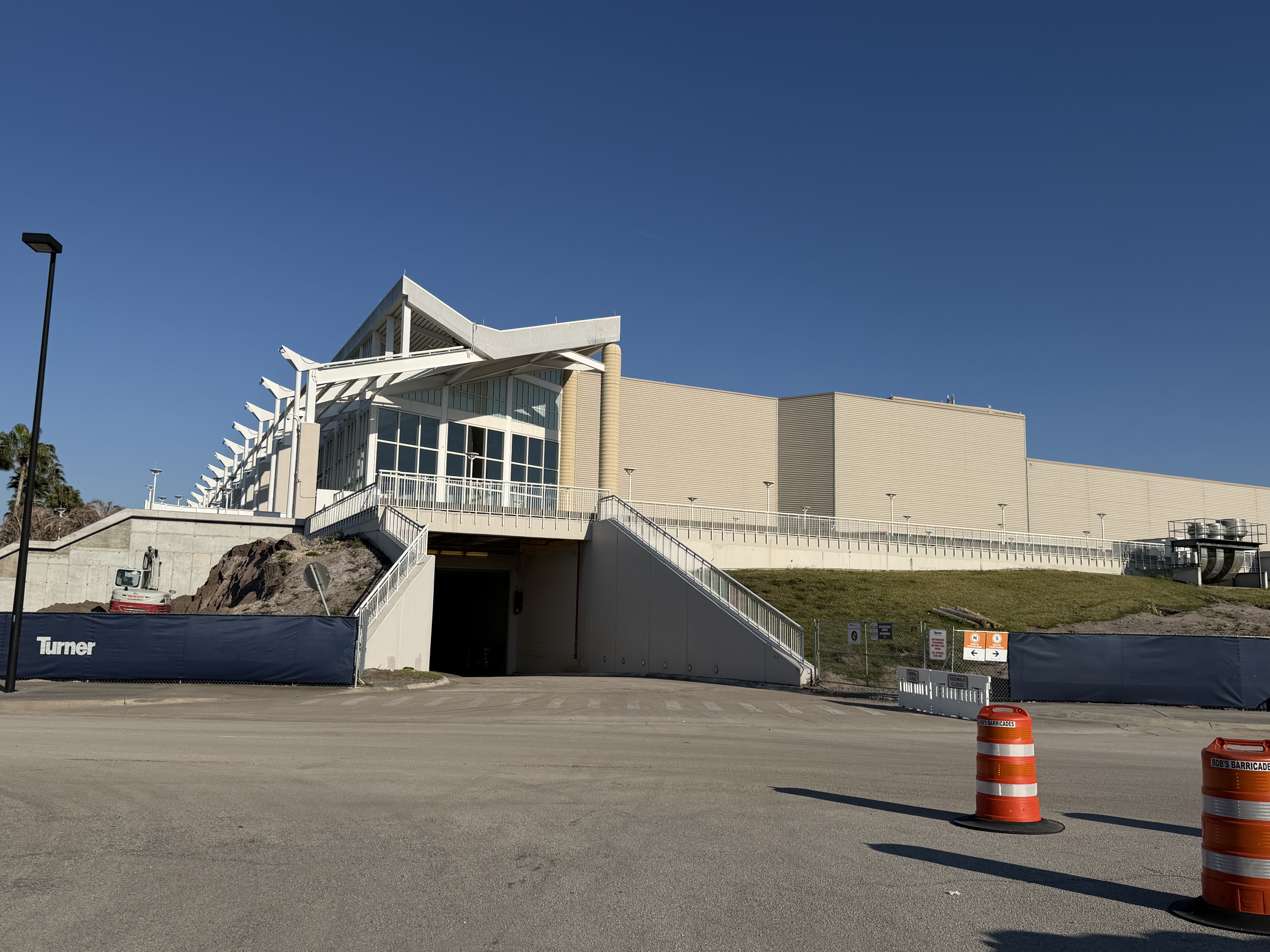
Orange County Convention Center, Orlando FL
North-South Building · Grand Concourse Expansion · 9800 International Dr · ~28.4259°N, -81.4707°W
92% · 6-anchor convergence
[OBS] PIL crop on wing-roof lobby + Lens matches: "OCCC stairs" (Clark Construction, Dreamstime, Populous)
[OBS] Turner fence · Bob's Barricades · N/S CONCOURSE wayfinding
[INF] Turner is CMAR on the $560M OCCC Grand Concourse Expansion · project literally cites "connection to existing North and South concourse"
[INF] Bob's Barricades operates FL/AZ only → FL biome lock
[OBS] photo 2026-03-21 = matches early-2026 groundbreaking
6-anchor convergence: Turner + Bob's + N/S + Lens + timing + ribbed cladding
open in maps →
[OBS] Turner fence · Bob's Barricades · N/S CONCOURSE wayfinding
[INF] Turner is CMAR on the $560M OCCC Grand Concourse Expansion · project literally cites "connection to existing North and South concourse"
[INF] Bob's Barricades operates FL/AZ only → FL biome lock
[OBS] photo 2026-03-21 = matches early-2026 groundbreaking
6-anchor convergence: Turner + Bob's + N/S + Lens + timing + ribbed cladding
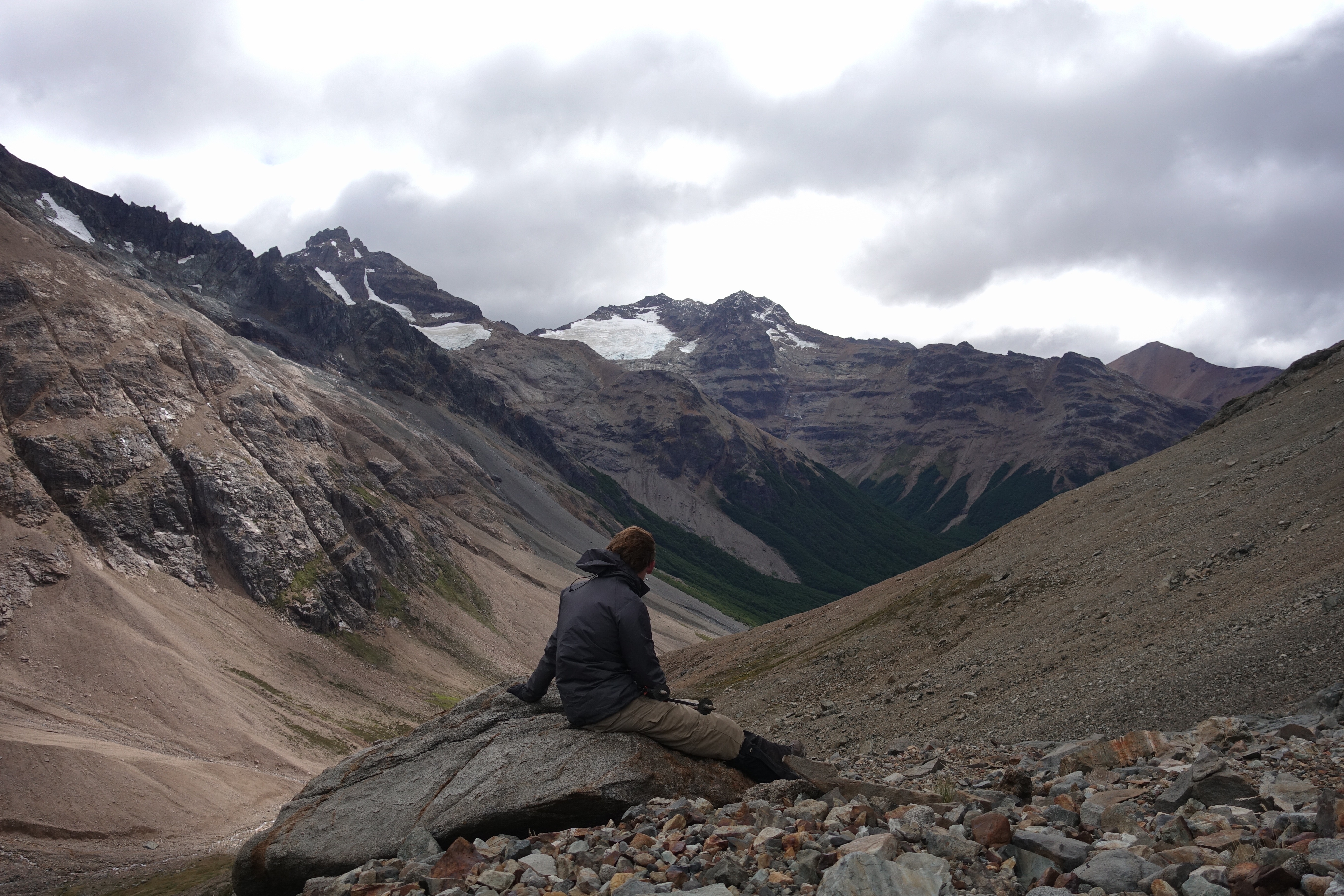
VIEWPOINT + W-TREK · 93%
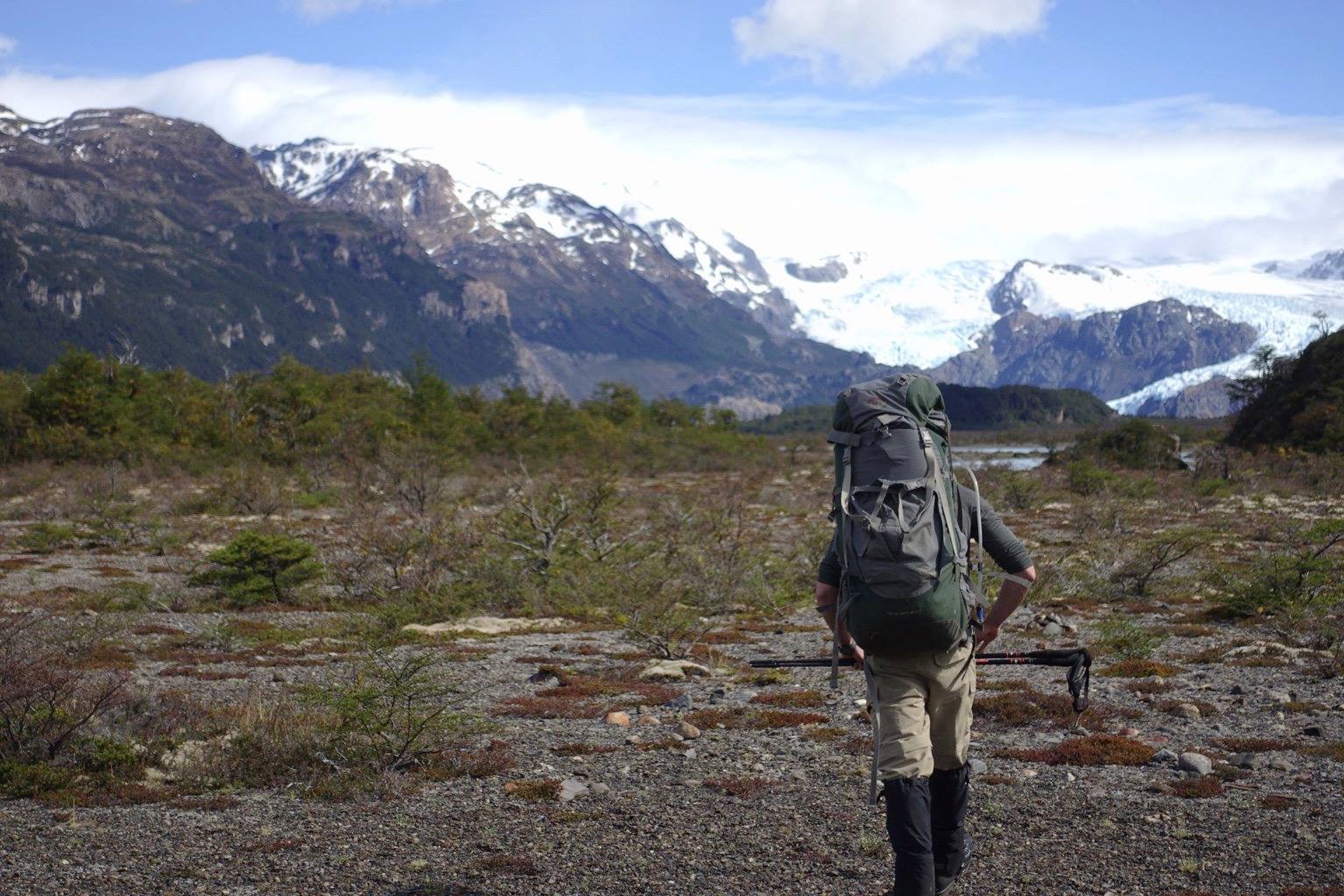
Glaciar Grey approach, Torres del Paine NP
~2 km south of Refugio Grey · W-trek west arm · Magallanes Region, Chile · -51.005°N, -73.175°W
93% · viewpoint match + cross-image
[OBS] hiker with multi-day W-trek pack walking through burn-zone scrub
[OBS] glacier tongue + grey silty lake visible at right edge
[INF] only Glaciar Grey has burn-scarred forest + this glacier-tongue access
cross-image — pairs with IMG_1246 (French Valley middle arm) as same W-trek trip ~12 km apart
open in maps →
[OBS] glacier tongue + grey silty lake visible at right edge
[INF] only Glaciar Grey has burn-scarred forest + this glacier-tongue access
cross-image — pairs with IMG_1246 (French Valley middle arm) as same W-trek trip ~12 km apart
VIEWPOINT + W-TREK · 92%
Mirador Británico, Valle del Francés, Torres del Paine NP
Upper French Valley · middle arm of W-trek · Magallanes Region, Chile · -50.970°N, -73.025°W
92% · viewpoint match + cross-image
[OBS] day-pack hiker on scree in classic U-shaped glacial trough
[OBS] dark granite cirque peaks · hanging snowfield at valley head · no lake visible
[INF] no-lake + cirque peaks = Mirador Británico — rules out all lakeshore viewpoints
cross-image with IMG_1217 = same W-trek, day-hike out of Paine Grande or Italiano
open in maps →
[OBS] dark granite cirque peaks · hanging snowfield at valley head · no lake visible
[INF] no-lake + cirque peaks = Mirador Británico — rules out all lakeshore viewpoints
cross-image with IMG_1217 = same W-trek, day-hike out of Paine Grande or Italiano
CITY-LOCK · 85%
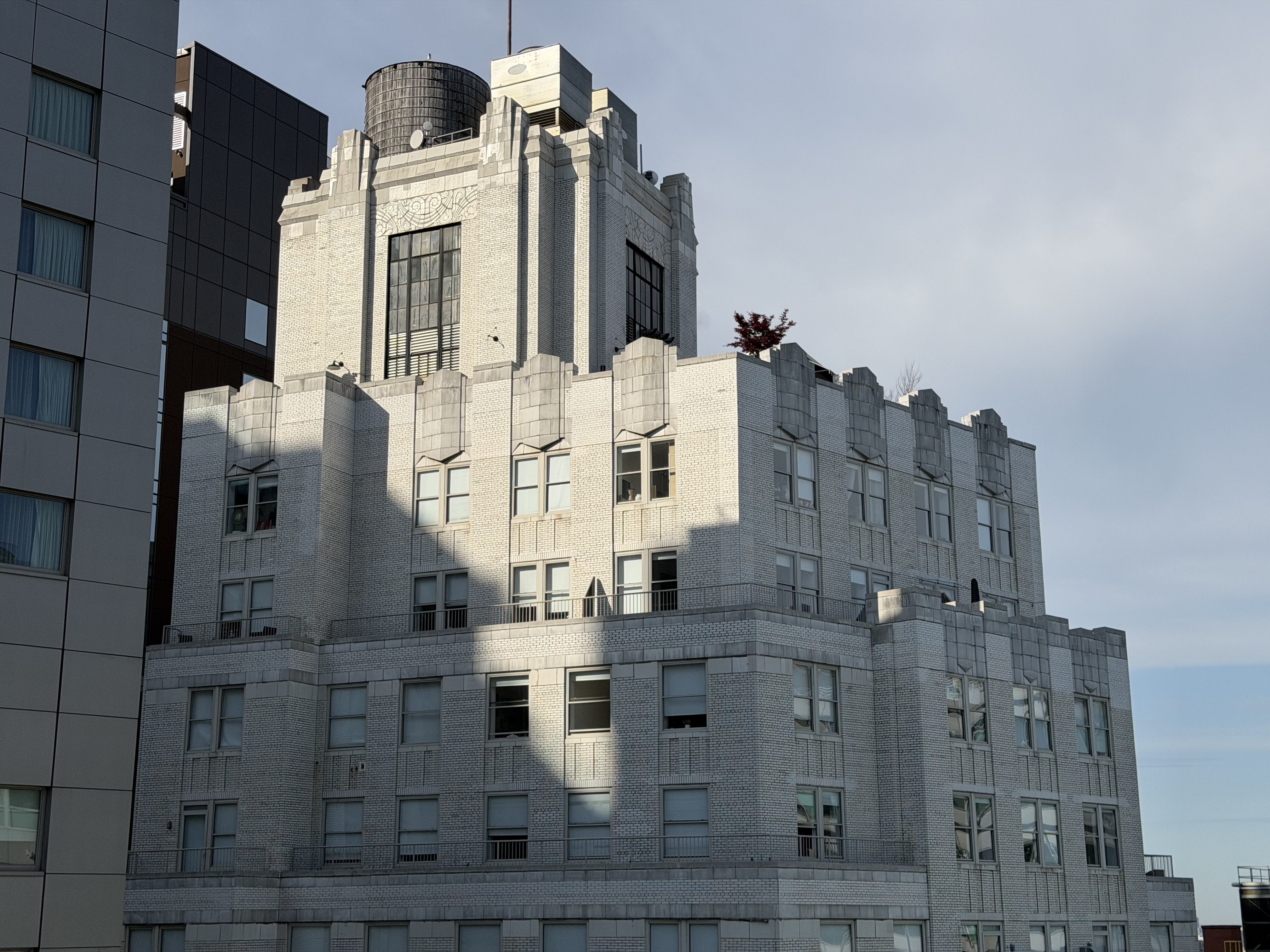
NYC · Upper West Side or West Village
Late-1920s/early-1930s Art Deco apartment · ~8 stories · specific building unresolved
85% · city + era · building TBD
[OBS] Art Deco setback · crenellated stepped parapet (4-tooth) · diamond-brick pattern
[OBS] rooftop wooden water tower visible — near-universal NYC signature
[INF] Vancouver RULED OUT (Marine Building is sea-green terracotta · Burrard Building is 1956 modernist)
[INF] NYC candidates evaluated via homography overlay tool — Master Apts (28-story wrong scale) · 2 Horatio St (red+brown brick) · Hampshire House (wrong massing) · The Mayan (indeterminate)
85% city-level honest hedge · discipline refused to ship a wrong-building specific lock · GeoCLIP Vancouver hypothesis correctly demolished
open in maps →
[OBS] rooftop wooden water tower visible — near-universal NYC signature
[INF] Vancouver RULED OUT (Marine Building is sea-green terracotta · Burrard Building is 1956 modernist)
[INF] NYC candidates evaluated via homography overlay tool — Master Apts (28-story wrong scale) · 2 Horatio St (red+brown brick) · Hampshire House (wrong massing) · The Mayan (indeterminate)
85% city-level honest hedge · discipline refused to ship a wrong-building specific lock · GeoCLIP Vancouver hypothesis correctly demolished
LENS + ROTARY · 95%
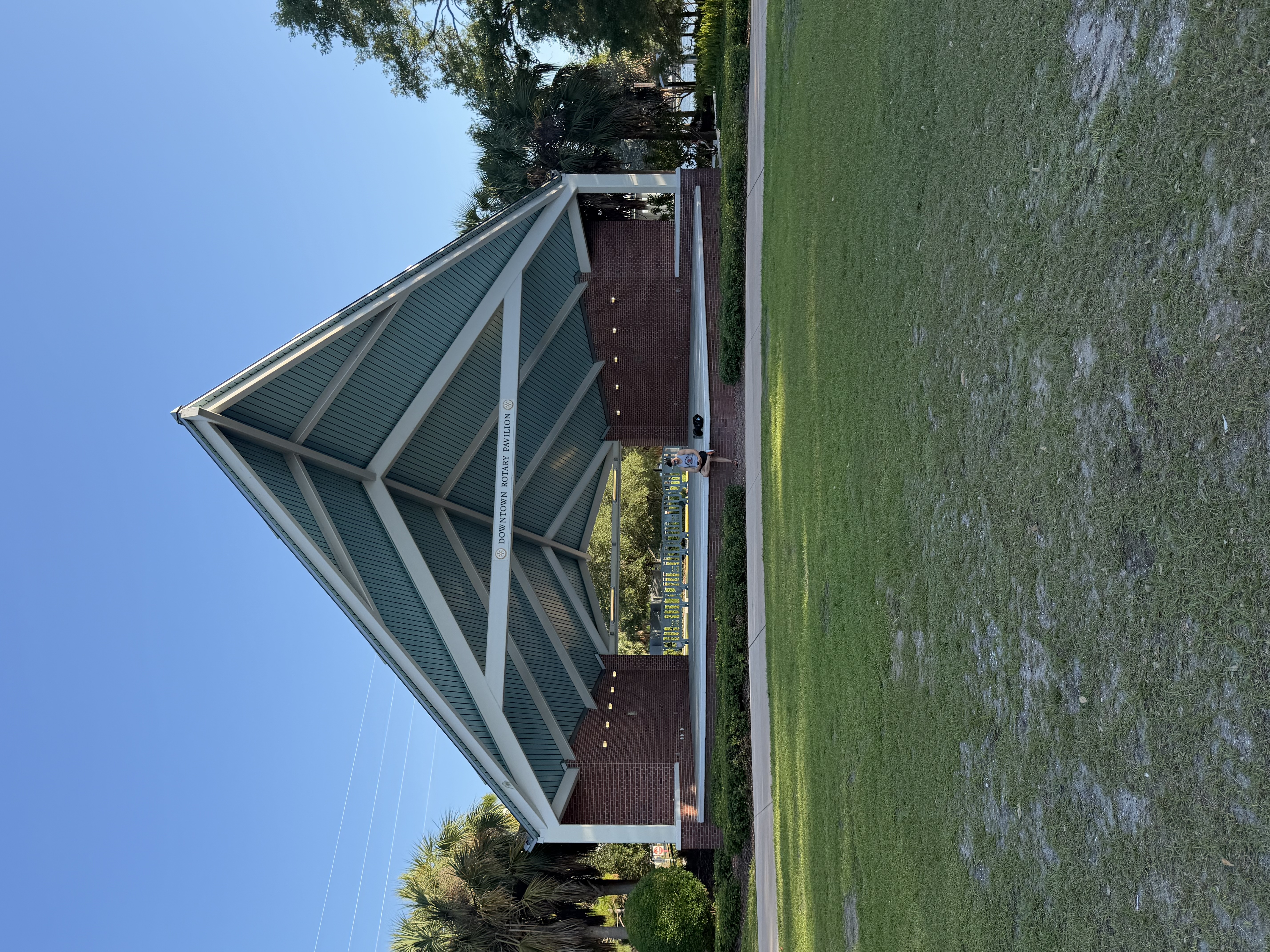
Downtown Rotary Pavilion · Water Works Park, Tampa FL
1710 N Highland Ave · Tampa FL 33602 · ~27.9606°N, -82.4595°W
95% · Lens tight-crop + Rotary archive
[OBS] sign reads "DOWNTOWN ROTARY PAVILION"
[INF] Google Lens on a tight sign crop → direct visual match captioned "Water Works Park / City of Tampa"
[INF] Tampa Rotary Club $40k naming-rights donation 2014 corroborates
Cross-image: same Tampa trip as IMG_1150 + IMG_1258 · 3-location Tampa cluster · methodology note — tight-crop Lens beat city enumeration
open in maps →
[INF] Google Lens on a tight sign crop → direct visual match captioned "Water Works Park / City of Tampa"
[INF] Tampa Rotary Club $40k naming-rights donation 2014 corroborates
Cross-image: same Tampa trip as IMG_1150 + IMG_1258 · 3-location Tampa cluster · methodology note — tight-crop Lens beat city enumeration
IMG_8584 — 22% · US Mid-Atlantic / Upper South suburb · Skyfield ran (degenerate case at 7:34 AM May 8 — sun azimuth only ~6° spread across CONUS) · retire-tier without more signals