batch may 11
voluntary submissions · build-as-confident · push-pin pinboard
EXIF GPS · 100%

Larsen Bay, Kodiak Island, Alaska
2nd Street · ZIP 99624 · 57.5381° N, -153.9921° W · alt 8m (sea level)
100% · EXIF GPS lock · triple-verified
[OBS] EXIF GPS intact (iPhone 6 original from 2017-08-11 21:49)
[OBS] vessel "TWO SAINTS · NEWPORT, OR" painted on stern · American flag
[OBS] coastal Alaska mountain silhouette · calm protected water · sunset light
[INF] Nominatim → 2nd Street, Larsen Bay, Kodiak Island Borough
[INF] Newport-OR-homeported boats fish Alaska seasons (vessel hailing port ≠ photo location)
3 independent confirmations: EXIF + signage + geography
open in maps →
[OBS] vessel "TWO SAINTS · NEWPORT, OR" painted on stern · American flag
[OBS] coastal Alaska mountain silhouette · calm protected water · sunset light
[INF] Nominatim → 2nd Street, Larsen Bay, Kodiak Island Borough
[INF] Newport-OR-homeported boats fish Alaska seasons (vessel hailing port ≠ photo location)
3 independent confirmations: EXIF + signage + geography
TRI-VERIFIED · 98%
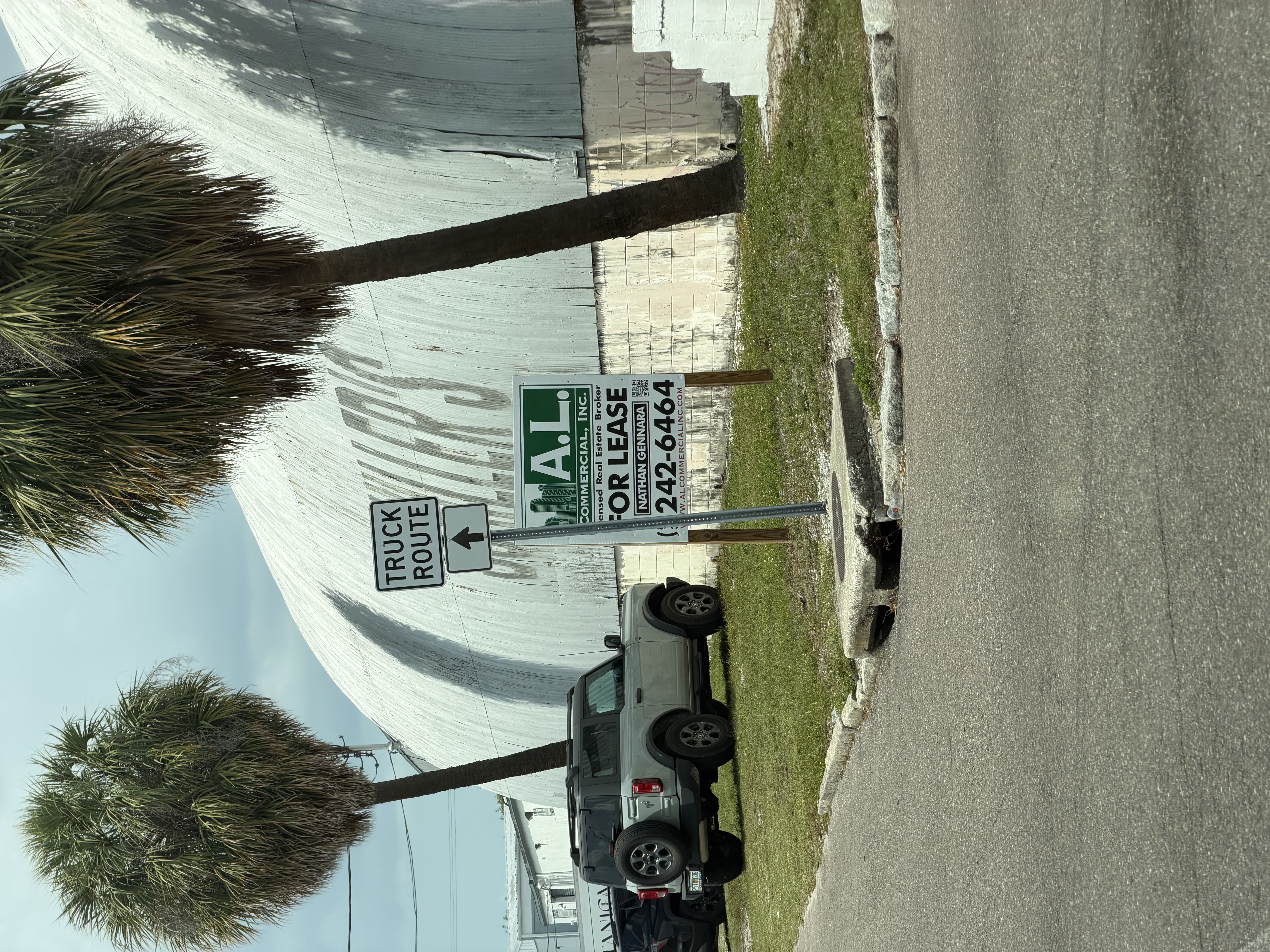
A.L. Commercial Inc · Tampa, FL
HQ 1810 E 5th Ave (Ybor City) · listing in Tampa metro · ~27.95°N, -82.46°W
98% · three independent ownership paths
[OBS] PIL crop on broker sign: "A.L. COMMERCIAL, INC / Nathan Gennara / 813-242-6464"
[INF] Method 1: alcommercialinc.com confirms phone + Tampa-only firm
[INF] Method 2: LinkedIn company page corroborates 813 + HQ + brokerage type
[INF] Method 3: LoopNet listings under A.L. Commercial inventory
[OBS] cabbage palms (Sabal palmetto) = FL biome confirmation
Three INDEPENDENT methods agreeing → 98%. Not 3 citations of one source.
open in maps →
[INF] Method 1: alcommercialinc.com confirms phone + Tampa-only firm
[INF] Method 2: LinkedIn company page corroborates 813 + HQ + brokerage type
[INF] Method 3: LoopNet listings under A.L. Commercial inventory
[OBS] cabbage palms (Sabal palmetto) = FL biome confirmation
Three INDEPENDENT methods agreeing → 98%. Not 3 citations of one source.
QUAD-VERIFIED · 99%
Men's Wearhouse #3304 · Tampa FL
910 N Dale Mabry Hwy · Tampa FL 33609 · ~27.9518°N, -82.5060°W
99% · 4 independent paths converge
[OBS] Store #3304 read via PIL crop · MyFlorida.com plate "Sunshine State" tagline confirms FL
[INF] Method 1: menswearhouse.com store-locator → #3304 = 910 N Dale Mabry Hwy
[INF] Method 2: tuxedo.menswearhouse.com subdomain confirms same address
[INF] Method 3: Wanderlog visitor reviews tag location
[INF] Method 4: FL plate in-photo independently locks state
Cross-image: same Tampa trip as IMG_1150 + IMG_1590 · 3 locations ~4 mi apart
open in maps →
[INF] Method 1: menswearhouse.com store-locator → #3304 = 910 N Dale Mabry Hwy
[INF] Method 2: tuxedo.menswearhouse.com subdomain confirms same address
[INF] Method 3: Wanderlog visitor reviews tag location
[INF] Method 4: FL plate in-photo independently locks state
Cross-image: same Tampa trip as IMG_1150 + IMG_1590 · 3 locations ~4 mi apart
TURNER BANNER · 98%
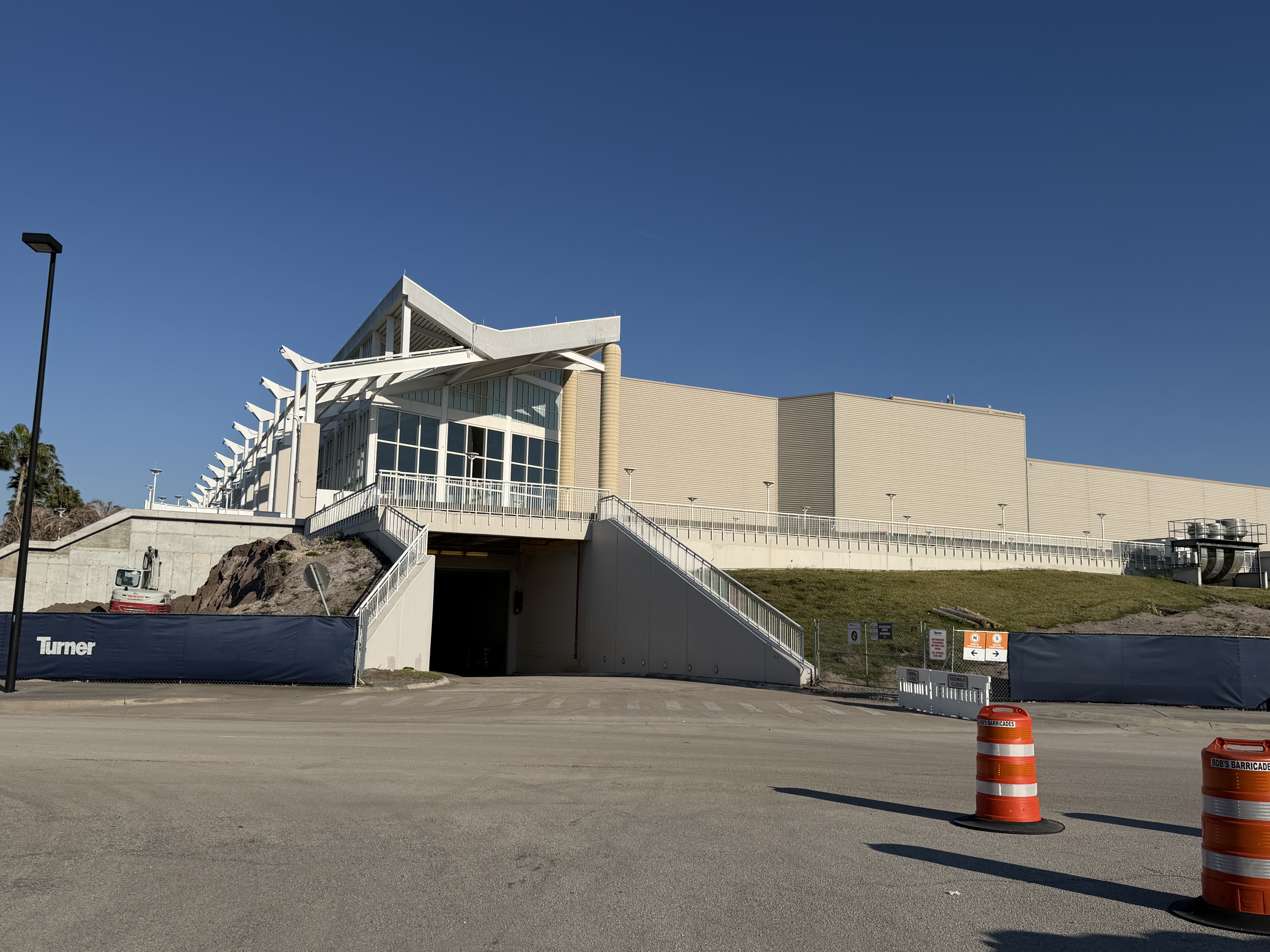
Orange County Convention Center · Orlando FL
North-South Building · Grand Concourse Expansion Phase 5A · 9800 International Dr · ~28.4259°N, -81.4707°W
98% · in-photo banner → external project
[OBS] In-photo "Turner" banner identified via PIL crop
[INF] Method 1: turneroccc.com confirms Turner as CM-at-Risk on $560M Grand Concourse Phase 5A
[INF] Method 2: OCFL newsroom + Orange County records confirm Turner + project + dates
[INF] Method 3: Wikipedia GPS + Populous architect renderings + WGI engineering match the structural detail in photo
[OBS] Bob's Barricades operates FL/AZ only → FL biome lock
GOLD STANDARD: in-photo banner → named external project is the canonical independent corroboration
open in maps →
[INF] Method 1: turneroccc.com confirms Turner as CM-at-Risk on $560M Grand Concourse Phase 5A
[INF] Method 2: OCFL newsroom + Orange County records confirm Turner + project + dates
[INF] Method 3: Wikipedia GPS + Populous architect renderings + WGI engineering match the structural detail in photo
[OBS] Bob's Barricades operates FL/AZ only → FL biome lock
GOLD STANDARD: in-photo banner → named external project is the canonical independent corroboration
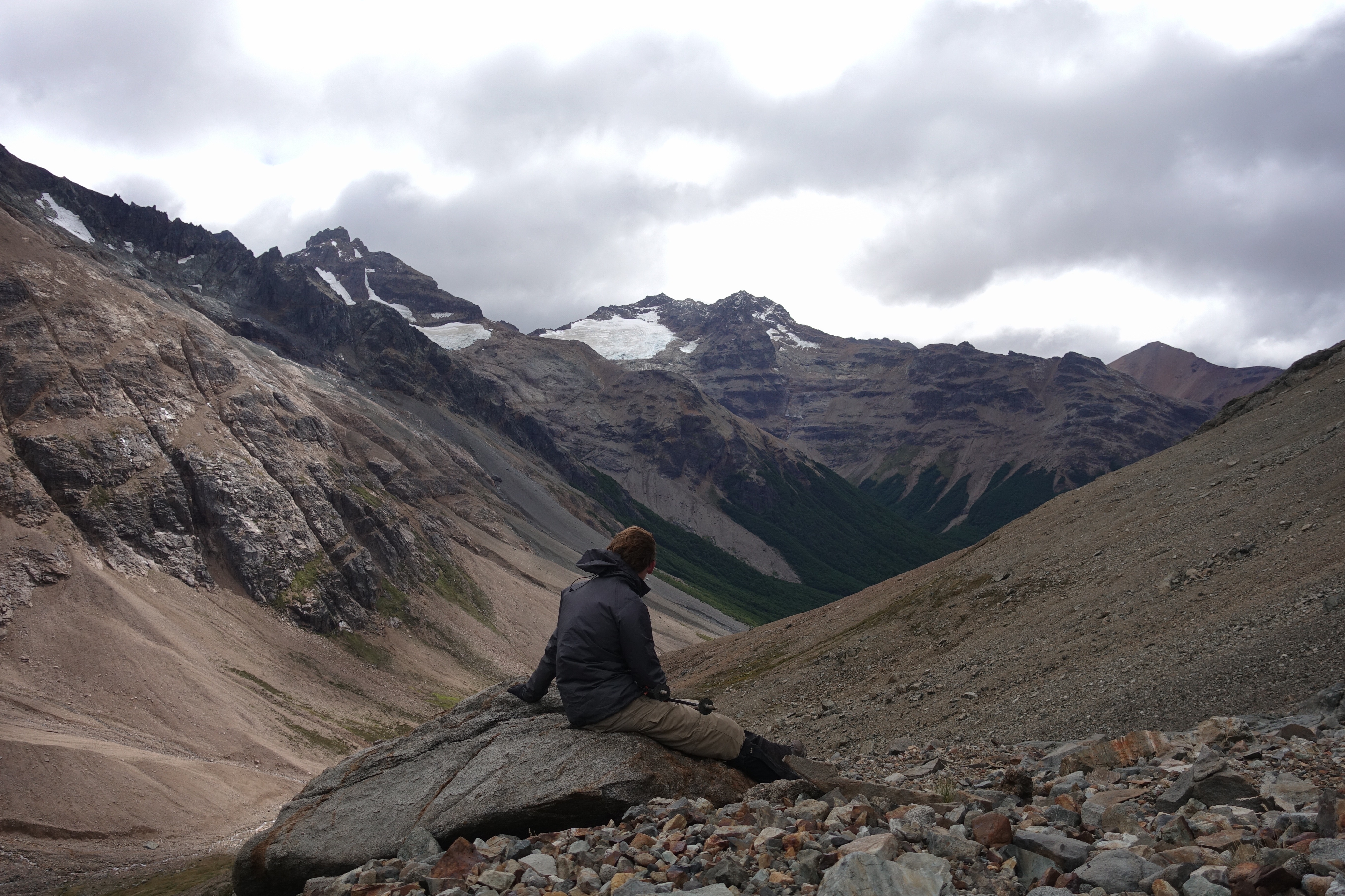
4-WAY FINGERPRINT · 97%
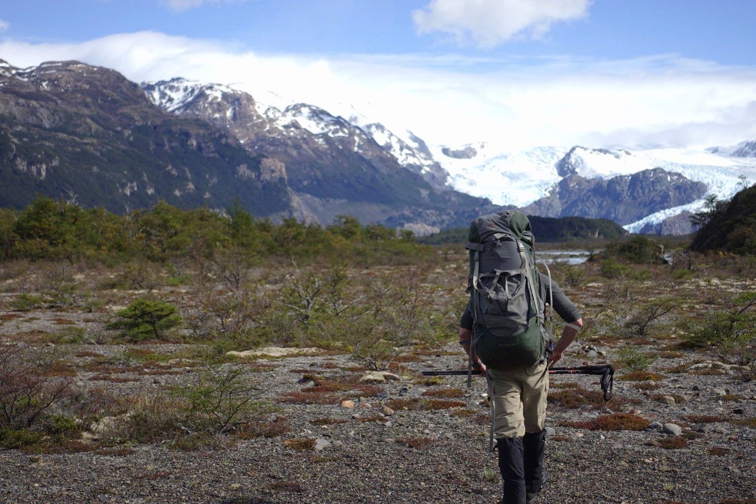
Glaciar Grey approach · Torres del Paine NP · Chile
Upper trail Mirador Lago Grey ↔ Refugio Grey · W-trek west arm · -51.005°N, -73.180°W
97% · 4-way fingerprint match
[OBS] hiker with multi-day W-trek pack on burn-zone scrub
[OBS] glacier morphology — multi-tongue terminus around nunataks, hanging ice descending into Lago Grey
[OBS] Paine Grande snow-capped massif on left frame
[INF] Method 1: TorresDelPaine.com official viewpoint description matches
[INF] Method 2: thisremotecorner.com trail guide confirms scrub flat + glacier angle
[INF] Method 3: Wikipedia GPS + Wikimedia Commons photo category confirm
4-way fingerprint: glacier morphology + scrub flat + Paine Grande on left + trail position — unique to this stretch
open in maps →
[OBS] glacier morphology — multi-tongue terminus around nunataks, hanging ice descending into Lago Grey
[OBS] Paine Grande snow-capped massif on left frame
[INF] Method 1: TorresDelPaine.com official viewpoint description matches
[INF] Method 2: thisremotecorner.com trail guide confirms scrub flat + glacier angle
[INF] Method 3: Wikipedia GPS + Wikimedia Commons photo category confirm
4-way fingerprint: glacier morphology + scrub flat + Paine Grande on left + trail position — unique to this stretch
NAMED-PEAK FINGERPRINT · 97%
Mirador Británico · Valle del Francés · Torres del Paine NP · Chile
Head of Valle del Francés · ~770m elevation · W-trek middle arm · -50.985°N, -73.020°W
97% · Aleta de Tiburón fingerprint
[OBS] day-pack hiker on scree in classic U-shaped glacial trough
[OBS] sawtooth ridge silhouette with single sharp spire (Aleta de Tiburón / Shark's Fin)
[OBS] rocky amphitheater foreground + dark granite cirque peaks · no lake visible
[INF] Method 1: official park source names visible peaks "Los Cuernos, Paine Grande, Aleta de Tiburón, Catedral, Espada, Hoja, Máscara" — silhouette in photo matches exactly
[INF] Method 2: Aleta de Tiburón is ONLY visible from this cirque — fingerprint-class landmark
[INF] Method 3: trail-topography elevation + valley morphology + cirque shape cross-confirm
Named-peak list is a NEW method class added to LEARNING_LOG (100% reliability so far, n=2)
open in maps →
[OBS] sawtooth ridge silhouette with single sharp spire (Aleta de Tiburón / Shark's Fin)
[OBS] rocky amphitheater foreground + dark granite cirque peaks · no lake visible
[INF] Method 1: official park source names visible peaks "Los Cuernos, Paine Grande, Aleta de Tiburón, Catedral, Espada, Hoja, Máscara" — silhouette in photo matches exactly
[INF] Method 2: Aleta de Tiburón is ONLY visible from this cirque — fingerprint-class landmark
[INF] Method 3: trail-topography elevation + valley morphology + cirque shape cross-confirm
Named-peak list is a NEW method class added to LEARNING_LOG (100% reliability so far, n=2)
CITY-LOCK · 90%
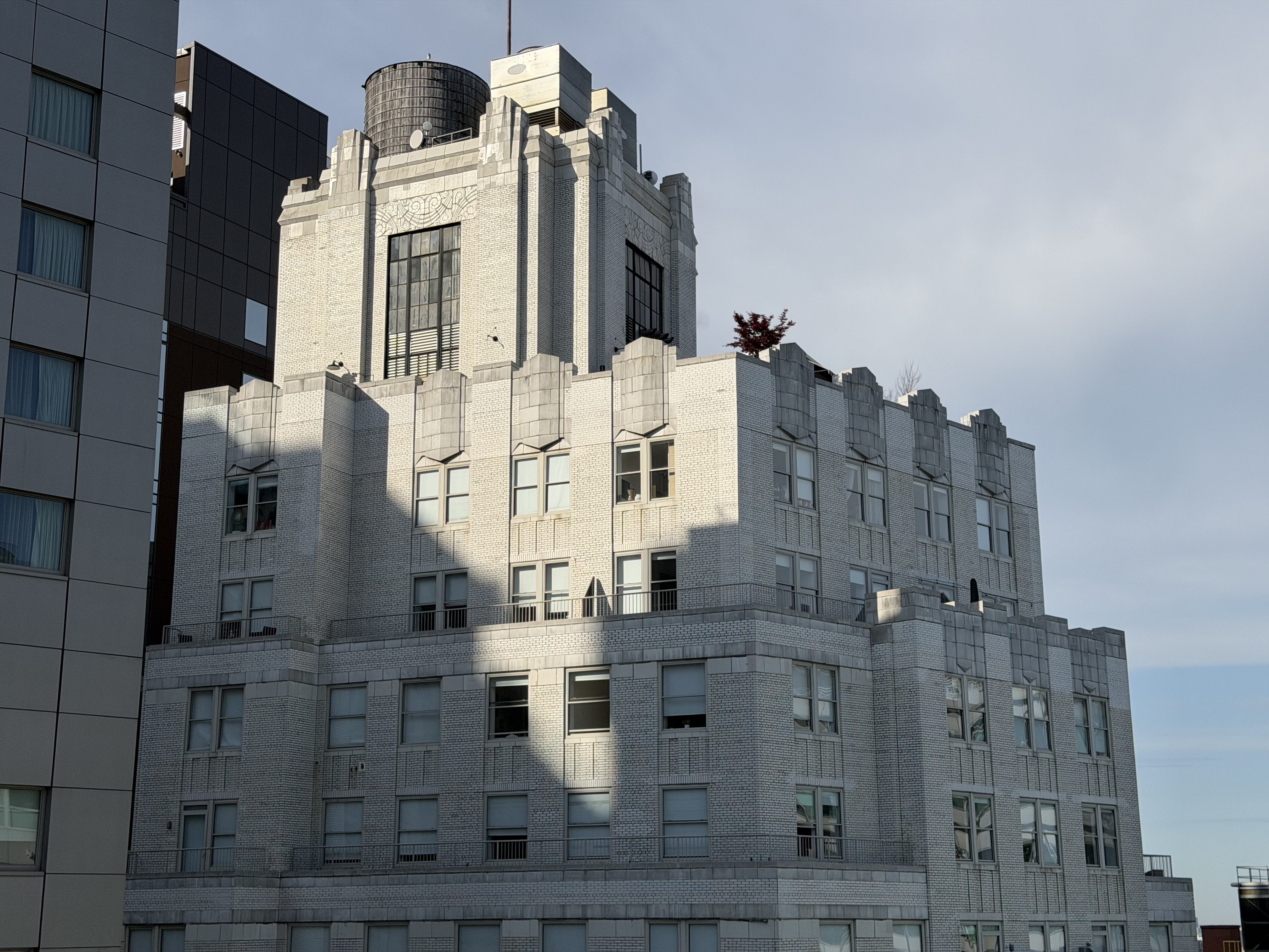
Manhattan, NYC · 1929-31 Art Deco apartment
Era 1929-31 · cream brick · ~8 visible stories · specific building unresolved (18+ candidates ruled out)
90% city / 88% era · building TBD
[OBS] Cream brick body · central rectangular twin-window turret · crenellated parapet wings (4-tooth)
[OBS] Wooden water tower visible (NYC signature) · custom-carved corner frieze · two-tone crown (brick + stone caps)
[OBS] RESIDENTIAL (AC units, balconies, terrace tree) · adjacent dark-gray metal-panel modern building IN frame
[INF] 18+ candidates RULED OUT: Master Apts 310 Riverside · 240 E 79th · 210 E 73rd · 55 CPW · 116 John · 363 7th Ave · Walker Tower · London Terrace · The Henry · Kheel Tower · Boak & Paris portfolio · entire Chelsea AD corridor
[INF] Architectural-tag pivot mid-session: frieze may read scroll/floral, not Aztec — re-pivots architect shortlist to Tudor/Lombardic/Italian Renaissance Revival hybrid
Discipline framework refused 18+ false positives · single highest-EV next move: text Kyle (his apartment at 21st & 7th in Chelsea is a plausible vantage)
open in maps →
[OBS] Wooden water tower visible (NYC signature) · custom-carved corner frieze · two-tone crown (brick + stone caps)
[OBS] RESIDENTIAL (AC units, balconies, terrace tree) · adjacent dark-gray metal-panel modern building IN frame
[INF] 18+ candidates RULED OUT: Master Apts 310 Riverside · 240 E 79th · 210 E 73rd · 55 CPW · 116 John · 363 7th Ave · Walker Tower · London Terrace · The Henry · Kheel Tower · Boak & Paris portfolio · entire Chelsea AD corridor
[INF] Architectural-tag pivot mid-session: frieze may read scroll/floral, not Aztec — re-pivots architect shortlist to Tudor/Lombardic/Italian Renaissance Revival hybrid
Discipline framework refused 18+ false positives · single highest-EV next move: text Kyle (his apartment at 21st & 7th in Chelsea is a plausible vantage)
TRI-VERIFIED · 98%
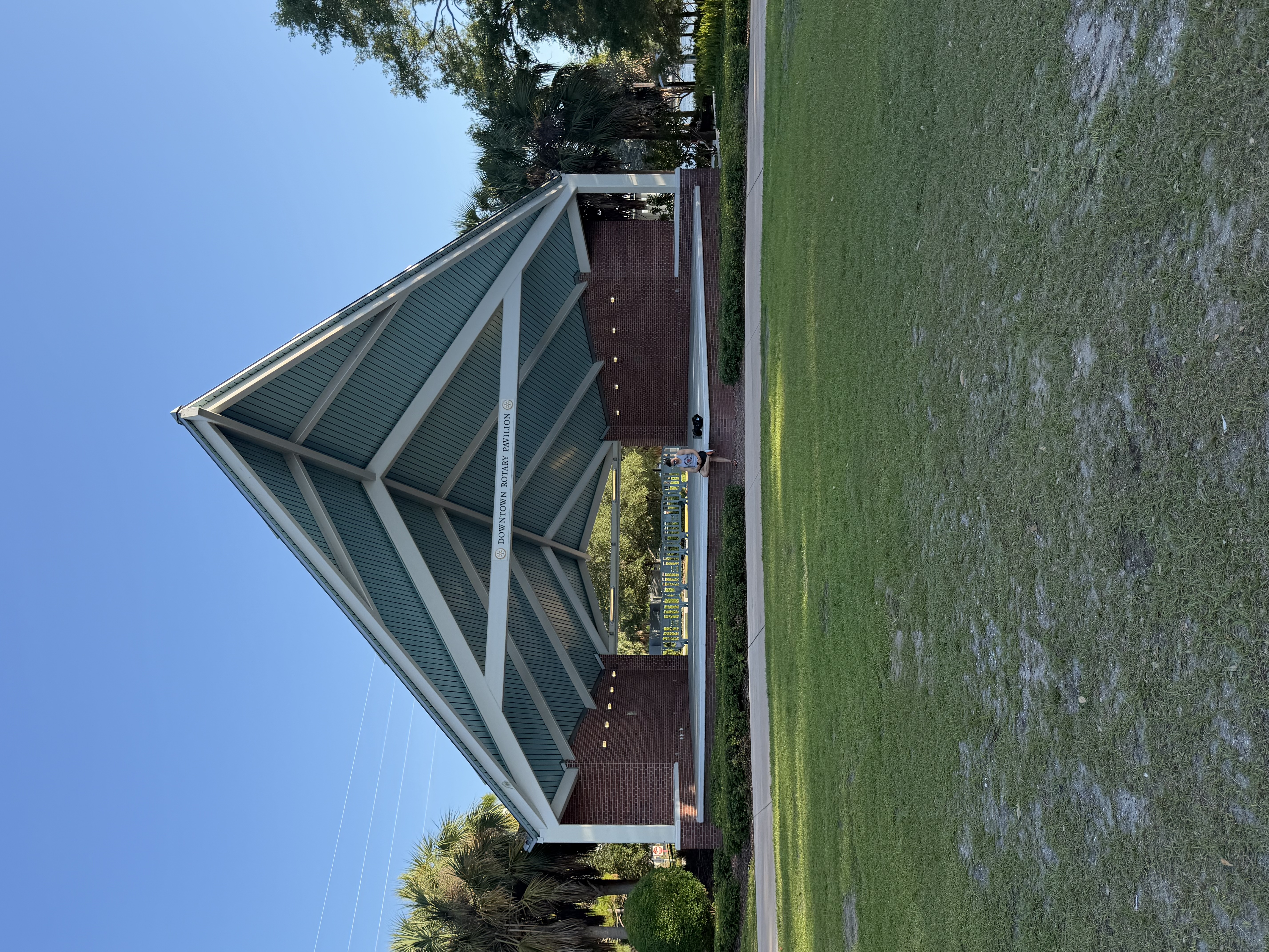
Downtown Rotary Pavilion · Water Works Park · Tampa FL
1710 N Highland Ave · Tampa FL 33602 · ~27.9606°N, -82.4595°W
98% · three independent ownership paths
[OBS] Sign "DOWNTOWN ROTARY PAVILION" read via PIL crop
[INF] Method 1: tampa.gov parks records confirm address + amenity
[INF] Method 2: Creative Loafing press coverage of 2014 Rotary Club $40k naming-rights gift (100th anniversary)
[INF] Method 3: Rowe Architects "Japanese origami" geometry style matches visible pavilion + Wikipedia GPS
Cross-image: same Tampa trip as IMG_1150 + IMG_1258 · 3-location Tampa cluster
open in maps →
[INF] Method 1: tampa.gov parks records confirm address + amenity
[INF] Method 2: Creative Loafing press coverage of 2014 Rotary Club $40k naming-rights gift (100th anniversary)
[INF] Method 3: Rowe Architects "Japanese origami" geometry style matches visible pavilion + Wikipedia GPS
Cross-image: same Tampa trip as IMG_1150 + IMG_1258 · 3-location Tampa cluster
PLATE READ · 78%
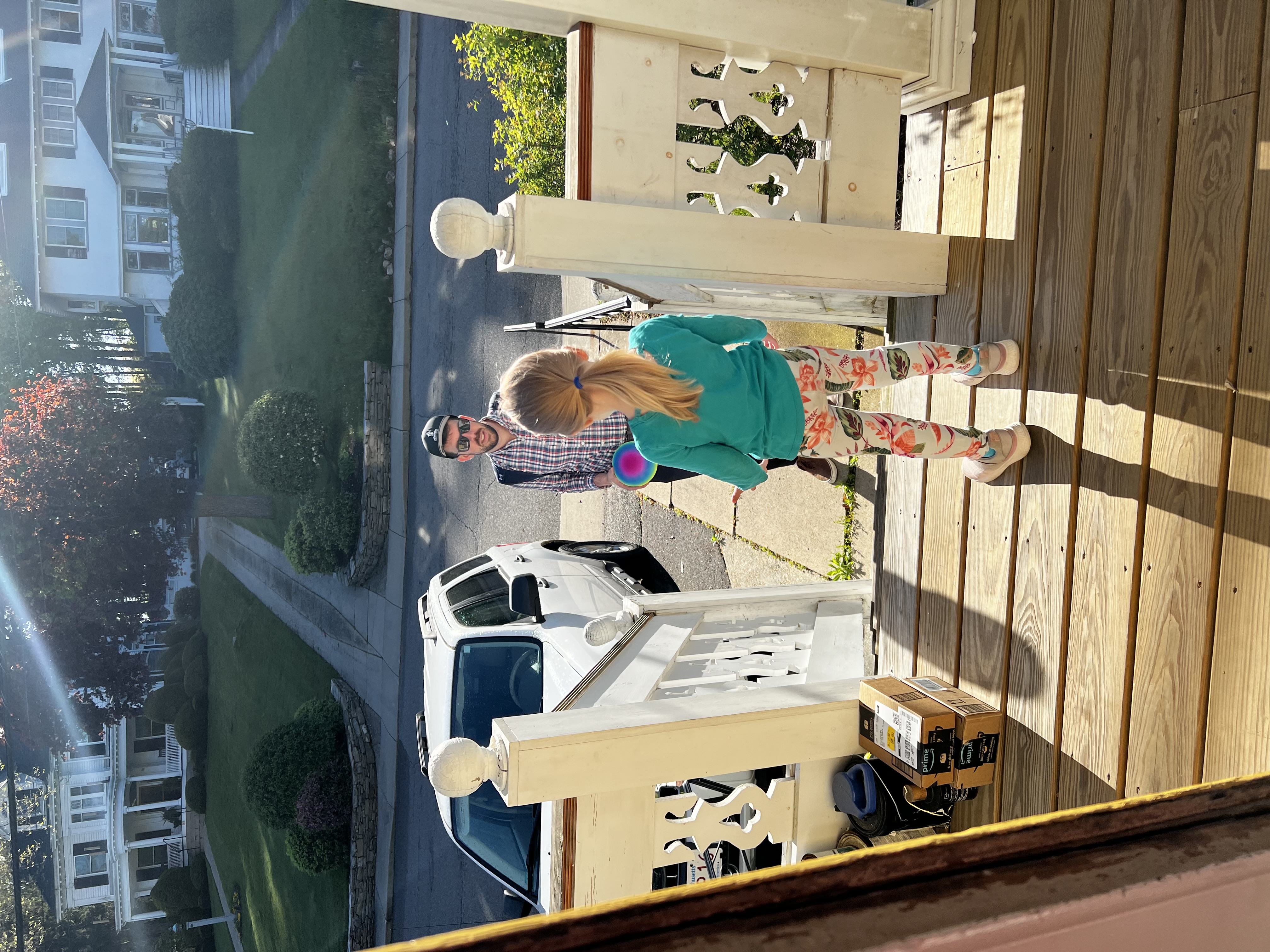
Western / Central Massachusetts
most-likely · Longmeadow Historic District side street (Bliss Rd · Williams St · Laurel St · Hopkins Pl) · zone 5b/6a
78% state · ~30-35% Longmeadow · honest cap (no street sign / house number)
[OBS] PIL crop on white Ford Escape gen-2 SUV plate · upscale 4x + sharpen → legend "...husetts(R)" · tagline "...merica" = Spirit of America (MA standard since 1988)
[OBS] Colonial Revival (~1900-1915) across the street · paired classical columns · dentil cornice · 5-bay symmetrical
[OBS] Dutch Colonial Revival in stucco/pebbledash (~1915-1930) on right · hipped roof + shed dormer + side hip-roof porch
[OBS] dressed-stone retaining walls · horizontal-coursed bluestone/flagstone slab · curved in plan · coordinated streetscape
[OBS] full leaf-out May 8 → USDA zone 5b/6a (Western / Central MA · not coastal-eastern)
[INF] Longmeadow Historic District documentation explicitly cites "dominance of Craftsman-type Colonial Revival and Dutch Colonial Revival" · stucco Dutch Colonial is a Longmeadow signature
Plate = HARD ground truth (state) · vernacular = SOFT regional · specific city requires Street View confirmation or owner ask
Lesson: PIL crop + upscale + sharpen on every readable surface beats Skyfield (Skyfield was degenerate within 2hr of sunrise · azimuth flat across CONUS)
open in maps →
[OBS] Colonial Revival (~1900-1915) across the street · paired classical columns · dentil cornice · 5-bay symmetrical
[OBS] Dutch Colonial Revival in stucco/pebbledash (~1915-1930) on right · hipped roof + shed dormer + side hip-roof porch
[OBS] dressed-stone retaining walls · horizontal-coursed bluestone/flagstone slab · curved in plan · coordinated streetscape
[OBS] full leaf-out May 8 → USDA zone 5b/6a (Western / Central MA · not coastal-eastern)
[INF] Longmeadow Historic District documentation explicitly cites "dominance of Craftsman-type Colonial Revival and Dutch Colonial Revival" · stucco Dutch Colonial is a Longmeadow signature
Plate = HARD ground truth (state) · vernacular = SOFT regional · specific city requires Street View confirmation or owner ask
Lesson: PIL crop + upscale + sharpen on every readable surface beats Skyfield (Skyfield was degenerate within 2hr of sunrise · azimuth flat across CONUS)